


Imray C Charts English Channel - Irish and North Sea
Imray Marine charts in medium and large scales covering the Irish Sea, North Sea, English Channel and Bay of Biscay
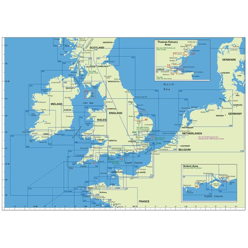
For larger maps, click on the images above, then record the number of the C chart required. Select your required charts from the C chart dropdown boxes at the top right of this page to order.
Imray C Charts offer coverage for cruising yachtsmen on larger size sheets. They are suitable for offshore passage planning and the medium scales allow safe inshore navigation.
- Detailed cartography
- Clear colour definition of shoal and drying areas
- Large-scale plans of harbours
- Tidal stream information based on the Admiralty pattern of 'diamonds' as well as the usual tidal constants; most charts include tidal stream diagrams
- Details of radio services
- Information on facilities for yachtsmen, where the scale of the chart is suitable, with telephone numbers
- Printed on the reverse is information concerning signs, symbols and abbreviations as well as useful general information about weather, tides and, where relevant, glossaries of foreign terms
- Large format folding enabling easier working
C01 Thames Estuary - Tilbury to North Foreland and Orfordness 1:120,000 WGS 84
C02 The River Thames - Teddington to Southend WGS 84 Teddington to Vauxhall 1:13,600 Vauxhall to Barking 1:15,200 Barking to Southend 1:40,400
C03 Isle of Wight Plans Continuation of Southampton Water, River Hamble, Lymington River, Bembridge Harbour 1:52,500 WGS 84
C04 Needles Channel to Bill of Portland Plans Weymouth, Swanage, Lulworth Cove, Christchurch, Studland Bay, Continuation of the River Stour 1:75,000 WGS 84
C05 Bill of Portland to Salcombe Harbour Plans Bridport, Lyme Regis, Exmouth, Torbay, Torquay, Brixham, Dartmouth 1:100,000 WGS 84
C06 Salcombe to Lizard Point Plans Fowey Approaches, Looe, Mevagissey, Charlestown, Polperro, Plymouth Sound, Falmouth 1:100,000 WGS 84
C07 Falmouth to Isles of Scilly and Newquay Plans St Mary's Road, Mousehole, Newlyn, St Ives, Porthleven, Penzance, Portreath, Newquay Bay, Hugh Town, Mullion Cove 1:100,000 WGS 84
C08 North Foreland to Beachy Head and Boulogne Plans Pegwell Bay, Ramsgate, Dover, Folkestone, Rye, Calais, Boulogne 1:115,000 WGS 84
C09 Beachy Head to Isle of Wight Plans Newhaven, Shoreham, Littlehampton, Brighton Marina, Portsmouth, Langstone and Chichester Harbours, Sovereign Harbour 1:110,000 WGS 84
C10 Western English Channel Passage Chart Radio Beacons, Lights, Tides 1:400,000 WGS 84
C12 Eastern English Channel Passage Chart Radio Beacons, Lights, Tides 1:300,000 WGS 84
C13 River Cleddau - Milford Haven to Haverfordwest 1:15,200 Approaches to Milford Haven 1:25,000 Plans Neyland Yacht Haven 1:6,250 Milford Marina 1:6,250 Inset continuation to Haverfordwest 1:37,500
C14 Plymouth Harbour and Rivers Plans River Tamar to Gunnislake, St German's River, Sutton Harbour and Queen Anne's Battery Marinas, Mayflower Marina 1:20,480 River Yealm 1:12,500
C15 The Solent - Bembridge to Hurst Point and Southampton Plans River Hamble, River Itchen, Yarmouth, Lymington, Beaulieu River, Wootton Creek, Newtown River, Cowes, Bembridge, Hythe Marina 1:35,000 WGS 84
C18 Western Approaches to the English Channel & Biscay Scale 1:686,000
C19 Cabo Finisterre to Gibraltar Plans Bayona, Lisboa Approaches, Viana do Castelo, Figueira da Foz, Bahia de Cadiz, Gibraltar, Lagos, Strait of Gibraltar 1:758,800
C20 Gibraltar to Arquipelago dos Acores and Islas Canaries 1:2.500.000 WGS 84
C23 Fife Ness to Moray Firth Plans Helmsdale, Inverness Firth, Inverness, Burghead, Hopeman, Buckie, Banff & Macduff, Fraserburgh, Peterhead, Aberdeen, Stonehaven, Montrose, Arbroath. 1:250,000
C24 Flamborough Head to Fifeness Plans Holy Island, Eyemouth, Berwick, Warkworth, River Tyne, Blyth, Seaham, Sunderland, Whitby, Hartlepool, River Tees, Scarborough 1:251,700
C25 Southern North Sea - Harwich to River Humber and Holland Plans Umuiden, Scheveningen, Den Helder, Oudeschild 1:340,000 WGS 84
C26 Southern North Sea - Umuiden to Die Elbe Plans Ilmuiden, Den Helder, Brunsbuttel, Lauwersoog, Cuxhaven, Helgoland, Norderney 1:343,000
C27 Firth of Forth Plans Kirkcaldy, Burntisland, St Andrews, Crail, Methil, Aberdour, N. Queensferry, Elie, Granton, Anstruther, St Monans, Pittenweem, Charlestown, Limekiln and Brucehaven, Dalgety Bay, Inverkeithing, Pettycur and Kinghorn, Port Edgar, Inchcolm, Grangemouth, Inchkeith, Port Seton, North Berwick, Leith, Cockenzie, Dunbar, Dysart 1:77,000
C28 The East Coast - Harwich to Wells-next-the-Sea Plans River Deben, Rivers Ore and Aide, Southwold, Lowestoft, Great Yarmouth, Blakeney, Wells-next-the-Sea 1:125,000 WGS 84
C29 Harwich to Whitby Plans River Humber, Hull Marina, Filey, Bridlington, Scarborough, Whitby 1:285,000 WGS 84
C30 Harwich and North Foreland to Hoek van Holland and Dover Strait Plans Dunkerque, Oostende, Zeebrugge, Vlissingen, Nieuwpoort, Breskens, Blankenberge 1:200,000 WGS 84
C31 Dover Strait to Le Havre Plans Dieppe, Fecamp, St-Valery en Caux, Le Havre, Boulogne, Le Treport, Sovereign Harbour, Approaches to the River Seine 1:200,000 WGS 84
C32 Baie de Seine - Le Havre to Cherbourg Plans Ouistreham, Cherbourg, St" Vaast-la-Hougue, Courseulles-sur-Mer, Port-en-Bessin, Trouville-Deauville, Barfleur, Baie du Grand Vey, Arromanches, Dives-sur-Mer, Le Havre Yacht Harbour, Honfleur, Grandcamp-Maisy, Port Chantereyne Marina 1:155,000 WGS 84
C33A Channel Islands Plans St Peter Port, Omonville, Goury, Portbail, Dielette, Carteret, Gorey, Alderney, Beaucette Marina, Creux Harbour Approaches, St Sampson, Little Russel 1:120,000 WGS 84
C33B Channel Islands (South) and North Coast of France Plans St Helier Yacht Harbours, St-Malo, Granville, Erquy, Binic, Dahouet, Pontrieux, St Helier Approaches, St-Malo Approaches 1:120,000 WGS 84
C34 Cap d'Erquy to Ile de Bats Plans Binic, St-Quay-Portrieux, R. de Treguier, Primel, R. !e Leguer, Port de Legue, Port Clos, Port de la Corderie, Anse de Perros, R. de Pontrieux and Paimpol, Port Blanc, Lezardrieux, Paimpol, Dahouet, Perros-Guirec 1:110,000 WGS 84
C35 Baie de Morlaix to l'Aber-lldut Plans lie de Batz, Approaches to L'Aber Wrac'h and L'Aber-Benoit, Argenton, Pontusval, Mogueriec, Port-Sail, L’Aber Ildut 1:76,600 WGS 84
C36 Ile d’Ouessant to Raz de Sein Plans Le Conquet, Port de Brest, Morgat, Camaret-sur-Mer, Douarnenez, Bate de Lampaul (Ouessant), Marina du Mouiin Blanc, Brest 1:77,300
C37 Raz de Sein to Benodet Plans Lesconii, Guilvinec, Benodet, Audierne, Loctudy, S. Guenole, L'Odet Fleuve, lie de Sein 1:77,800
C38 Anse de Benodet to Presquitle de Quiberon Plans Le PoEdu, Port de Foret, Concarneau, Port Maria, L'orient Yacht Harbour, Port Tudy, Etel, Brigneau & Merrien, Port Manech, Loc Maria, Lomener, Doelan 1:78,500
C39 Lorient to Le Croisic Plans La Trinite-sur-Mer, Le Croisic, La Turbaiie, Port de Crouesty, Port Haiiguen, Le Pouliguen, Pornichet, La Paiais 1:78,500
C40 Le Croisic to Les Sables d'Olonne Plans Loinville, Pornic, St-Nazaire, Goulet de Fromentine, St-Gilies-Croix de Vie, Les Sables d'Olonne, Le Croisic, L'Herbaudiere 1:109,000
C41 Les Sables d'Olonne to La Gironde Plans Jard-sur-IVIer, Bourgenay, Ars-en-Re, St-Martin-de-Re, La Fiotte-en-Re, Rochefort, Douhet, St-Denis d'Oleron, Rade de Pallice, Boyardvilie, La Rochelie and Port des Minimes, Royan 1:109,400
C42 Embouchure de la Gironde to Bordeaux and Arcachon Plans Royan, Pauiliac, Port Bioc, Bordeaux, Arcachon, La Garonne to Bordeaux, La Dordogne to Libourne 1:127,000
C48 La Coruna to Porto Plans Ria de Vivero, Ria de Cedeira, Ria de Ares and Betanzos, La Coruna, Ria de Camarinas, Ria de Munros, Ria de Arosa, Ria de Vigo, Viana do Castelo, Rias Corme and Lage, Ria Pontevedra 1:350,000
C49 Porto to Sines Plans Figuera de foz, Nazare, Cascais, Lisboa, Sines, Viano do Castelo, Povoa de Varzim, Leixoes, Setubal. 1:350,000
C50 Sines to Gibraltar Plans Sines, Portimao, Vilamoura, Vila Real de St Antonio and Ayamonte, Isla Christina, Mazagon, Chipiona, Puerto, Sherry, Sancti-Petri, Barbate, Tarifa, Gibraltar
C51 Cardigan Bay — Milford Haven to Tremadoc Bay Plans Pwllheli, Aberdovey, Fishguard, Aberystwyth, Cardigan, Aberaeron, New Quay Bay, Newport Bay, Aberporth, Milford Haven Entrance 1:140,800
C52 Cardigan Bay to Liverpool Plans Caernarfon, Port Dinorwic, Holyhead, Menai Strait, Porthmadog, Abersoch, Mochras Lagoon, Pwl!he!i, Conwy, Port Dinllaen, The Swetiies, Barmouth 1:138,600
C53 Donegal Bay to Rathlin Island Plans Kiiiybegs, Teelin, Lough Swiiiy, Portrush, Mulroy Bay, Sheep Haven, MulSaghmore Bay, Gweedore Harbour & Approaches/Sound of Arran & Burtonport 1:191,200 WGS 84
C54 Galway Bay to Donegal Bay Plans Siigo Harbour, Broad Haven Bay, Portnafrankagh (Frenchport), Westport, Inishbofin, AchiSI Sound, Cieggan Bay, Clifden Bay, Approaches to Roundstone 1:197,000
C55 Dingle Bay to Galway Bay Plans Fenit !s!and, Foynes Island, Limerick, Kilrush, Kilronan (Aran Islands), Ga!way Bay, Gaiway Harbour, Cashia, Dingle Harbour, River Shannon 1:200,640
C56 Cork Harbour to Dingle Bay Plans Baltimore, Castle Haven, Bantry, Crookhaven, Castletown, Bearhaven, Portmagee, Courtmacsherry, Dingle, Glengarriff, Sneem, Ardgroom and Kilmakilloge, Schull, Vaientia, Giandore, Kinsale 1:170,000
C57 Tuskar Rock to Old Head of Kinsale Plans Dungarven, Waterford, Youghal, Cork Lower Harbour, Crosshaven, Kinsale, Dunmore East, Kilmore 1:167,000
C58 Trevose Head to Bull Point Plans Barnstaple and Bideford, River Came!, Ilfracombe, Bude Haven, Port Isaac and Portgavern 1:131,300
C59 Bristol Channel — Worms Head and Bull Point to Sharpness Plans, Porthcawl, The Mumbles, Avonmouth, Bridgwater Bay & Burnham-on-Sea, Watchet, Minehead, Swansea Marina, Penarth. Inset Severn Bridge to Sharpness 1:114,500
C60 Gower Peninsula to Cardigan Plans Jack Sound, Milford Haven, Ramsey Sound, Tenby and Caidy Islands, Fishguard, Solva, Broad Haven and Little Haven 1:127,700
C61 St George's Channel Wales to the East Coast of Ireland Plans Portmadoc, Aberystwyth Tremadoc Bay, Barmouth, Menai Strait, Aberdovey, Cardigan, New Quay, Dublin Bay, Wexford, Arklow, Wicklow, Dunmore East 1:270,000
C62 Irish Sea Plans Entrance to Carlingford Lough, Portavogie, Skerries Bay, KHkeel Harbour, Maiahide Inlet, Ardglass, Entrance to Strangford Lough 1:280,000
C63 Firth of Clyde Plans Rhu & Helensburgh, Rothesay, Millport, Burnt Islands, Largs Channel, Lamlash, Caladh, Irvine, Kip Marina, Largs Yacht Haven, Troon, Girvan, Ayr, Portpatrick, Stranraer, Campbeltown, Campbeltown Loch, East Loch Tarbert, Crinan Approaches, Dumbarton/ Ardrishaig, Gourock 1:160, 500
C64 North Channel — Belfast Lough to Lough Foyle and Crinan Plans Loch Sween (Tayvallich), Port Ellen, West Loch Tarbert, West Loch Tarbert Lower Part, River Foyle to Londonderry, Larne, Belfast Lough, Portrush, Donaghadee Sound 1:150,000
C65 Crinan to Mallaig and Barra Plans Sound of Luing, Lynn of Lorn, Tobermory, Castle Bay, MaHaig, Entrance to Caledonian Canal, Oban 1:150,000
C66 Mallaig to Rudha Reidh and Outer Hebrides Plans St Kilda, East Loch Tarbert, Loch Maddy, Loch Carnan, Loch Boisdale, Dunvegan, Portree, Loch Gairloch, Kyleakin, Uig 1:150,000
C67 North Minch and Isle of Lewis Plans Loch Inver, Stornoway, Ullapool, Loch Inchard (Kinlochbervie) Loch Carloway 1:146,000
C68 Cape Wrath to Wick the Orkney Islands Plans Wick, Kirkwael, Stromness, Pierowall Whitewall Harbour, Scrabster 1:162,100
C70 Southern North Sea Passage Chart 1:950,000 WGS 84