


Garmin GPSMAP 60CSx Handheld GPS Unit
With the Garmin GPSMAP 60CSx Handheld GPS Unit you can find your way in almost any conditions.
Go anywhere, land or sea, with the 60CSx!
Perfect for both outdoor and marine use, the GPSMAP 60CSx features a high-sensitivity GPS receiver giving you improved satellite reception even in heavy tree cover or deep canyons.
The GPSMAP 60CSx is a refreshing upgrade of the popular GPSMAP 60CS. Featuring a microSD card slot located inside the waterproof battery compartment and an included blank 64 MB microSD card, optional map detail can be stored to the card for use with the GPSMAP 60CSx. The microSD card slot is also compatible with pre-programmed microSD cards from Garmin (sold separately) that provide topographic maps, city streets and nautical charts.
The GPSMAP 60CSx is compatible with most Garmin MapSource products including BlueChart, City Navigator, US Topo and Recreational Lakes with fishing hotspots. Users can load map data and transfer routes and waypoints through the unit's fast USB connection.
With a 2.6-inch, 256-colour TFT display, the 60CSx is designed to present mapping and trip information clearly and accurately in any lighting conditions. The case is lightweight, rugged and water-resistant to IEC 60529 IPX7 standards, meaning it can be submerged in up to 1 metre of water for 30 minutes.
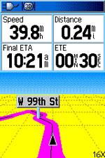
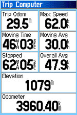
When driving, the GPSMAP 60CSX's fast processor will give auto turn-by-turn directions and the integrated trip computer will provide an odometer, stopped time, moving average, overall average, total time, max speed and more.
Incorporating a barometric altimeter, the GPSMAP 60CSx will provide extremely accurate elevation data and with an electronic compass displays your accurate heading whilst standing still.
In addition to the many practical functions of the 60CSx, it is also packed with fun features. An integrated outdoor calendar provides the ideal hunting and fishing times and also moon rise/set/location information. For those interested in the hot worldwide community scavenger hunt that is Geocaching, the GPSMAP 60CSx is geocaching-friendly featuring a dedicated geocaching mode. There are also a host of indoor and outdoor GPS games to help you and your friends enjoy the great outdoors and navigating around.
Screenshots
 |
 |
Large colour TFT |
Featuring a powerful SiRF GPS navigation chip, the GPSMAP 60CSx boasts supreme accuracy in all conditions. |
GPSMAP 60CSx Features
- New high-sensitivity WAAS-capable GPS receiver by SiRF
- Built-in quad-helix receiving antenna with remote antenna capability
- Electronic compass displays accurate heading while standing still
- Barometric altimeter with automatic pressure-trend recording
- Turn-by-turn routing on roads
- Geocaching-friendly
- Outdoor GPS games
- microSD card slot allows for storage of optional MapSource detail (64 MB microSD included)
- LED backlit display and keypad
- Internal memory is preloaded with a marine point database
- 1000 user waypoints with name and graphic symbol; 50 reversible routes
- Position formats include Lat/Long, UTM, Loran TDs, Maidenhead, MGRS, user grid and more
- Audible alarms for anchor drag, arrival, off-course, proximity waypoint and clock
- Large-numbers option for easy viewing; dual-position display mode
- Trip computer provides odometer, stopped time, moving average, overall average, total time, max speed and more
- Custom POIs - ability to add additional points of interest
- Elevation computer provides current elevation, ascent/descent rate, minimum/ maximum elevation, total ascent and descent, average and maximum ascent and descent rate
- Navigation instructions can be shared with repeaters, plotters and autopilots using NMEA protocols through the dedicated serial port
- Built-in celestial tables for sun and moon calculations and the best times to fish and hunt
- Compatible with most MapSource products including BlueChart, City Navigator, US TOPO 24K, US TOPO and Recreational Lakes with Fishing Hot Spots
- Water resistance: IEC 60529 IPX7 standards
Package Includes
- GPSMAP 60CSx unit
- 64 MB microSD
- Belt clip
- USB interface cable
- MapSource Trip & Waypoint Manager CD
- Lanyard
- Owner's manual
- Quick-Start guide
Physical & Performance
- Unit Dimensions (W x H x D): 6.1 x 15.5 x 3.3 cm
- Display Size (W x H): 3.8 x 5.6 cm
- Display Resolution (W x H): 160 x 250 pixels
- Display Type: 256-level colour TFT
- Weight: 213 g with batteries
- Battery: 2 x AA batteries (not included)
- Battery Life: 18 hours
- Waterproof: Yes (IPX7)
- Floats: No
- High-Sensitivity Receiver: Yes
- Interface: Serial and USB
Maps and Memory
- Basemap: Yes
- Preloaded Maps: No
- Ability to Add Maps: Yes
- Built-in Memory: No
- 64 MB microSD card included
- Waypoints/Favourites/Locations: 1000
- Routes: 50
- Track Log: 10,000 Points/20 Saved Tracks - lets you retrace your steps in both directions
Unavailable