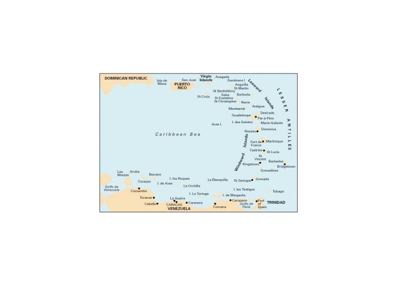
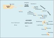
Imray Charts for the Caribbean provide coverage of popular areas on sheets especially designed for the needs of yachtsmen.
The only comprehensive and coherent series of yachting charts available. The 45 sheets cover Puerto Rico, the Virgin Islands, the Leeward Islands, the Windward Islands, Barbados and Venezuela.
Pilotage notes. Many of the charts in the series now include sailing directions on the reverse side.
Designed under the guidance of D M Street Jnr who has 40 years of unrivalled first-hand knowledge of the area.
Excellent value. Each Imray lolaire Chart provides ideal coverage of familiar cruising grounds at workable scales. Large scale plan inserts cover harbours and anchorages in detail. A single Imray lolaire Chart does the work of several of its rivals.
Produced by Imray Laurie Norie & Wilson Ltd in the United Kingdom, publishers of nautical charts since the 18th century. Imray lolaire Charts were first launched in 1979 and are produced to the high standard that has come to be associated with the oldest private chart publisher in the world.
Each sheet is printed on durable waterproof paper., which is ideal for charter boats where wear and tear is considerable.
Based on the latest official and local hydrographic surveys and with permission. All charts in the series are now either based on WGS 84 datum or related to WGS datum by offsets so that satellite-derived positions may be plotted.
Imray-lolaire charts are corrected to the time that they are despatched from Imray's offices and further corrections are available from our website www.imray.com or on request.
New editions incorporating major new surveys are published at frequent intervals.
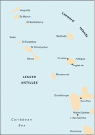
A - Puerto Rico to Martinique, 1:1,000,000 - Virgin and Leeward Islands. Passage Chart.
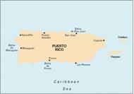
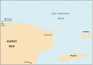
A1 - Puerto Rico, 1:285,000 - Passage Chart. Plans: San Juan, Bahia de Ponce, Puerto Arecibo, Bahia de Mayaguez.
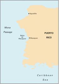
A11 - Bahia de Guanica to Punta Borinquen, 1:116,700 - West Coast of Puerto Rico. Plans: Bahia de Mayaguez, Puerto Real, Bahia de Boqueron, Approaches to La Parguera.
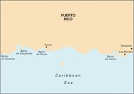
A12 - Punta Figuras to Bahia de Guanica, 1:116,700 - South Coast of Puerto Rico. Plans: Puerto Arroyo, Bahia de Ponce, Bahia de Jobos, Bahia de Guanica, Bahia de Guayanilla, Isla Caha de Muertos, Punta Petrona.
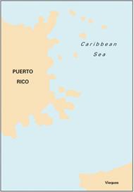
A13 - Cabo San Juan to Culebra Is and Punta Figuras, 1:116,700 - South-East Coast of Puerto Rico. Plans: Pasaje Medio Mundo, Ensenada Honda, Palmas del Mar, Puerto Arroyo & Puerto Patillas.
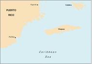
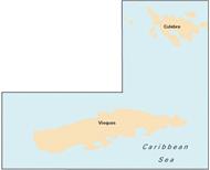
A131 - Isla de Culebra & Isla de Vieques, Various scales - Isla de Culebra 1:33,500. Isla de Vieques 1:44,500. Plans: Esperanza, Ensenada Honda
A14 - San Juan to Isla de Vieques & Isla de Culebra, 1:116,700 - Puerto Rico. Plans: Cayo Lobos, Marina Puerto Chico & Villa Marina, El Conquisitor Marina and Las Croabas, Isleta Marina, Isla Palominos, Bahia de San Juan, Puerto del Rey Marina.
A141 - Cabo San Juan to Ensenada Honda and Isla de Vieques, 1;40,000 - Plan: Marina del Rey
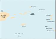
A2 - Puerto Rico to the Virgin and Leeward Islands, 1:400,000 - Virgin Islands Passage Chart Plan: Sombrero Island
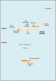
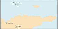
A23 - Virgin Islands and St Croix, Various scales - Virgin Islands 1:285,000 WGS 84 and St Croix 1:100,000 WGS 84. Plans: Christiansted, Port Alucroix & Limetree Bay, Frederiksted, Green Cay Marina, Road Harbour and Charlotte Amalie
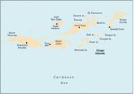
A231 - St Thomas to Virgin Gorda - Plans included: Charlotte Amalie (St Thomas), Cruz Bay (St John), Road Harbour, Sea Cow Bay & Nanny Cay Marina (Tortola), Virgin Gorda Yacht Harbour (Virgin Gorda), Great Camanoe to Scrub Island. 2010 Edition - Shows the harbour developments at Road Harbour. A new inset plan - Great Camanoe to Scrub Island - added, showing approaches to the new marina on Scrub Island.
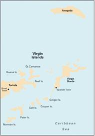
A232 - Tortola to Anegada, 1:90,000 - Plans included: Road Harbour & Approaches (Tortola), Virgin Gorda Yacht Harbour (Virgin Gorda), South Sound (Virgin Gorda), Gorda Sound (Virgin Gorda), Great Camanoe to Scrub Island. 2010 Edition - Shows the harbour developments at Road Harbour. A new inset plan - Great Camanoe to Scrub Island - added, showing approaches to the new marina on Scrub Island.
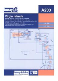
A233 - Virgin Islands (A231 and A232), 1:90,000 - Double-sided sheet display charts A231 and A232. A231 St Thomas to Virgin Gorda. Plans: Charlotte Amalie (St Thomas), Cruz Bay (St John), Road Harbour, Sea Cow Bay & Nanny Cay Marina (Tortola), Virgin Gorda Yacht Harbour (Virgin Gorda), Great Camanoe to Scrub Island. A232 Tortola to Anegada. Plans: Road Harbour & Approaches (Tortola), Virgin Gorda Yacht Harbour (Virgin Gorda), South Sound (Virgin Gorda), Gorda Sound (Virgin Gorda), Great Camanoe to Scrub Island
A234 - Northeast Coast of St Croix, 1:27,700 - Caribbean Sea, Virgin Islands. Plans: Salt River Bay, Christiansted Harbour, Green Cay Marina.
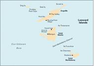
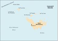
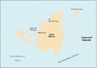
A24 - Anguilla, St Martin and St Barthélémy, 1:100,000 - Plans included: Road Bay, Oyster Pond, Port de Gustavia, Prickly Pear Cays, Crocus Bay, Shoal Bay and Island Harbour, Groot Baai, Grand Etang de Simsonbaai and Baie de Marigot, Anse de Marigot. 2011 Edition - Shows port development at Groot Baai; revised survey data, new dredged channels and marina developments at Grand Etang de Simsonbaai; plus revisions in the approaches to Gustavia.
A241 - St Barthelemy - Plan Gustavia 1:33,800 - Metric Edition
A242 - St Martin, 1:48,900 - Metric Edition
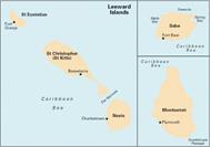
A25 - St Christopher, St Eustatius, Nevis, Montserrat & Saba, 1:100,000 - Includes insets: Saba (1:30 000), Monserrat (1:100 000), Plans included: Fort Baai (Saba), Basseterre Bay (St Kitts), The Narrows, Charlestown (Nevis), Oranjebaai (St Eustatius). 2012 Edition - Fully updated throughout. Shows the Christophe Harbour Marina currently under construction on St Christopher; revised depths in Fort Baai (Saba); and better positional detail around Charlestown.
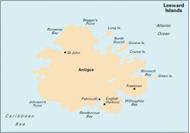
A27 - Antigua, 1:50,000 - Leeward Islands. Plans: Nonsuch Bay, Mamora Bay, Falmouth and English Harbours.
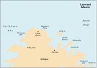
A271 - North Coast of Antigua, 1:35,000 - Leeward Islands
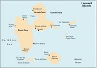
A28 - Guadeloupe, 1:150,000 - Leeward Islands. Plans: Pointe-à-Pitre, Pointe-à-Pitre Approaches, Anse Deshaies, Gosier, Port Louis, Ste François and Marina de la Grande Saline, Marine de Rivière Sens, Iles de la Petite Terre.
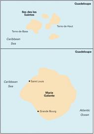
A281 - Les Saintes & Marie - Galante, 1:20,000/1:75,000 - Leeward Islands - Guadeloupe. Plans: Grand-Bourg (Marie-Galante), Grande Anse (Desirade). Plans on Guadeloupe: Ste-Anne & Anse Accul, Sainte-Marie, Petit Havre, Le Moule, N Approach to Pointe-a-Pitre.
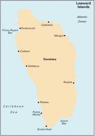
A29 - Dominica, 1:75,000 - Leeward Islands. Plans: Prince Rupert and Douglas Bay, Woodbridge Bay and Roseau Roads.
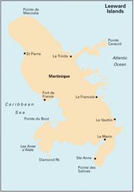
A30 - Martinique, 1:95,000 - Windward Islands. Plans: Pointe du Bout, St Pierre, Cul-de-Sac Marin, Havre du Robert, Rade de Fort de France, Havre de la Trinite, Mouillage du François.
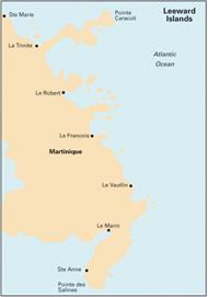
A301 - Pointe du Diamant to Havre de la Trinité, 1:60,000 - Windward Islands - South and East Coasts of Martinique. Plans: Cul-de-Sac Marin, Havre de la Trinite.
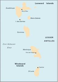
A4 - Guadeloupe to St Lucia, 1:400,000 - Lesser Antilles. Passage Chart.
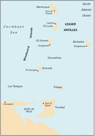
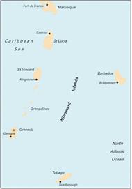
B - Martinique to Trinidad, 1:750,000 - Lesser Antilles - Windward Islands. Passage Chart.
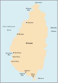
B1 - St Lucia, 1:75,000 - Windward Islands. Plans: Port Castries, Grand Cul de Sac Bay, Marigot Harbour, Rodney Bay & Yacht Harbour, Laborie Bay, Vieux Fort Bay & Point Sable Bay, Soufrere Bay & the Pitons.
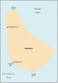
B2 - Barbados, 1:60,000 - Plans included: Port St Charles, Speightstown, Bridgetown (North), Bridgetown (South). 2012 Edition - Fully updated throughout. Harbour changes and new depth surveys have been applied to Bridgetown.
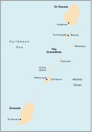
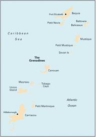
B3 - The Grenadines, 1:200,000 - Windward Islands - Passage Chart. St Vincent to Grenada.
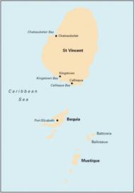
B30 - St Vincent to Mustique, 1:90,000 - Windward Islands - The Grenadines (North Sheet). Plans included: Chateaubelair Bay (St Vincent), Kingstown Bay (St Vincent), Calliaqua Bay & Blue Lagoon (St Vincent), Admiralty Bay (Bequia), Friendship Bay (Bequia), Baliceaux & Battowia, West Coast Of Mustique. 2009 Edition - First digitally-drawn edition, providing improved clarity and enhanced definition of detail.
B31 - Bequia to Carriacou, 1:90,000 - Windward Islands - The Grenadines (Middle Sheet). Plans included: Charlestown Bay (Canouan), Tobago Cays, Clifton Harbour (Union Island), Hillsborough Bay (Carriacou). 2009 Edition - First digitally-drawn edition, providing improved clarity and enhanced definition of detail.
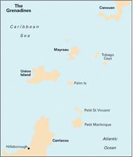
B311 - Middle Grenadines - Canouan to Carriacou, 1:32,500 - 2009 Edition - Now digitally drawn for improved clarity and enhanced definition.
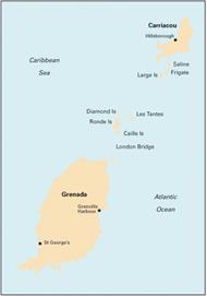
B32 - Carriacou to Grenada, 1:90,000 - Windward Islands - The Grenadines (South Sheet). Plans included: Tyrrel Bay (Carriacou), Grenada Bay, Grenville Harbour, Grenada - South Coast, Saint George’s Harbour. 2009 Edition - First digitally drawn edition, providing improved clarity and enhanced definition of detail.
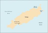
B4 - Tobago, 1:65,000 - Plans included: Man of War Bay, Tyrrel's Bay, King's Bay, Scarborough, Buccoo Reef, Plymouth. 2009 Edition - Now digitally drawn for improved clarity and enhanced definition.
B5 - Martinique to Grenada, Tobago and Barbados, 1:500,000 - Windward Islands. Passage Chart.
B6 - Grenada to Tobago and Trinidad, 1:375,000 - Includes plan of Chaguaramus Bay. 2009 Edition - Now drawn digitally for improved clarity and enhanced definition.
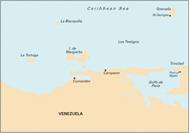
D - Gulf of Paria to Curaçao, 1:1,021,000 - Caribbean Sea - Venezuela. Passage Chart.
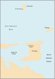
D1 - Port of Spain to Cabo Codera, 1:583,700 - Venezuela. Passage Chart. Plans: Port of Spain, Carenero, Chaguaramus.
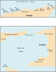
D10 - North Coast of Trinidad and Golfo de Paria, 1:145,000/ 1:234,000 - Caribbean Sea. North Coast of Trinidad 1:145,000. Golfo de Paria 1:234,000. Plans: Macqueripe, La Vache Bay, Maracas Bay, Las Cuevas Bay, Chupara Bay, Grande Riviere Bay, Toco Bay, Matelot Bay, Sans Souci Bay, Point Fortin, Pointe a Pierre, Brighton, Guiria, Ensenada Patao, Ensenada Uquirito, Ensenada Cariaquita.
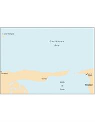
D11 - Trinidad to Carupano, 1:240,700 - Venezuela. Plans: Guira, Port of Spain, Carupano, Ensenada Cariaquita, Ensenada Pargo, Ensenada Mejillones, Playa Cacao, Ensenadas Patao & Uquirito, Macuro, Ensenada Uquire, Bahias Puerto Santos, Carupano, Ensenada Yacua, Ensenada San Francisco.
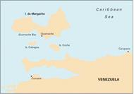
D12 - Carupano to Cumana and Isla de Margarita, 1:173,000 - Venezuela. Plans: Pampatar, Bahia de Mangle, Bahia Escondida, Punta de Piedras, Porlamar, Cumana, Laguna Grande del Obispo, Margarita Marina, El Saco (Isla Coche).
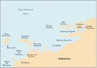
D13 - Isla de Margarita to Carenero, 1:255,000 - Venezuela. Plans: Carenero, Islas Piritu, Cumana.
D131 - Puerto Mochima to Bahia de Barcelona, 1:63,900 - Venezuela. Plans: Americo Vespucio Marina & El Morro, Marina Club Nautico El Morro, Puerto la Cruz Marina, Bahias Bergantin, Guanta & Pertigalete, Puerto Mochima
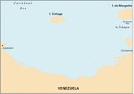
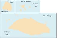
D14 - Islas los Testigos, Isla La Tortuga, La Blanquilla, 1:30,000/1:60,000 - Venezuela. Islas los Testigos 1:30,000, Isla la Tortuga 1:60,000, La Blanquilla 1:60,000. Plan: Laguna el Carenero.
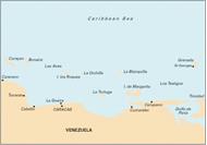
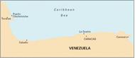
D2 - Cabo Codera to Cabo San Roman, 1:583,700 - Caribbean Sea - Venezuela. Passage Chart. Plans: Puerto Carenero, Puerto Cabello.
D21 - Carenero to Punta San Juan, 1:244,400 - Venezuela. Plans: Puerto la Cruz, Puerto Cabello, Puerto Chichiriviche and Parque National Morrocoy, Bahia San Juan, Ensa de Corsarios, Higuerote, Puerto Carenero, Puerto Calera, Puerto la Guaira, Puerto Azul, Carabelleda YC & Marina Mar.
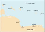
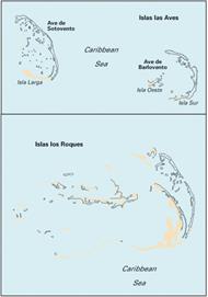
D22 - Isla los Roques and Isla de Aves, 1:89,700/ 1:65,900 - Venezuela. Isla los Roques 1:89,700. Plans: Puerto el Roque, Eastern end of Carenero, Cayo de Agua. Isla de Aves 1:64,900. Plans: Lighthouse Island, Long Island, Round Island, Eastern end Barlovento.
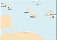
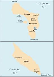
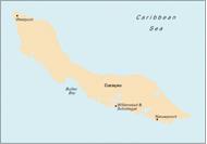
D23 - Punta Aguide to Cabo San Roman and the A, B, C Islands, 1:255,400 - Venezuela. Plans: Puerto Cumarebo, Oranjestad.
Imray Charts for the Caribbean provide coverage of popular areas on sheets especially designed for the needs of yachtsmen.
The only comprehensive and coherent series of yachting charts available. The 45 sheets cover Puerto Rico, the Virgin Islands, the Leeward Islands, the Windward Islands, Barbados and Venezuela.
Pilotage notes. Many of the charts in the series now include sailing directions on the reverse side.
Designed under the guidance of D M Street Jnr who has 40 years of unrivalled first-hand knowledge of the area.
Excellent value. Each Imray lolaire Chart provides ideal coverage of familiar cruising grounds at workable scales. Large scale plan inserts cover harbours and anchorages in detail. A single Imray lolaire Chart does the work of several of its rivals.
Produced by Imray Laurie Norie & Wilson Ltd in the United Kingdom, publishers of nautical charts since the 18th century. Imray lolaire Charts were first launched in 1979 and are produced to the high standard that has come to be associated with the oldest private chart publisher in the world.
Each sheet is printed on durable waterproof paper., which is ideal for charter boats where wear and tear is considerable.
Based on the latest official and local hydrographic surveys and with permission. All charts in the series are now either based on WGS 84 datum or related to WGS datum by offsets so that satellite-derived positions may be plotted.
Imray-lolaire charts are corrected to the time that they are despatched from Imray's offices and further corrections are available from our website www.imray.com or on request.
New editions incorporating major new surveys are published at frequent intervals.
A - Puerto Rico to Martinique, 1:1,000,000 - Virgin and Leeward Islands. Passage Chart.
A1 - Puerto Rico, 1:285,000 - Passage Chart. Plans: San Juan, Bahia de Ponce, Puerto Arecibo, Bahia de Mayaguez.
A11 - Bahia de Guanica to Punta Borinquen, 1:116,700 - West Coast of Puerto Rico. Plans: Bahia de Mayaguez, Puerto Real, Bahia de Boqueron, Approaches to La Parguera.
A12 - Punta Figuras to Bahia de Guanica, 1:116,700 - South Coast of Puerto Rico. Plans: Puerto Arroyo, Bahia de Ponce, Bahia de Jobos, Bahia de Guanica, Bahia de Guayanilla, Isla Caha de Muertos, Punta Petrona.
A13 - Cabo San Juan to Culebra Is and Punta Figuras, 1:116,700 - South-East Coast of Puerto Rico. Plans: Pasaje Medio Mundo, Ensenada Honda, Palmas del Mar, Puerto Arroyo & Puerto Patillas.
A131 - Isla de Culebra & Isla de Vieques, Various scales - Isla de Culebra 1:33,500. Isla de Vieques 1:44,500. Plans: Esperanza, Ensenada Honda
A14 - San Juan to Isla de Vieques & Isla de Culebra, 1:116,700 - Puerto Rico. Plans: Cayo Lobos, Marina Puerto Chico & Villa Marina, El Conquisitor Marina and Las Croabas, Isleta Marina, Isla Palominos, Bahia de San Juan, Puerto del Rey Marina.
A141 - Cabo San Juan to Ensenada Honda and Isla de Vieques, 1;40,000 - Plan: Marina del Rey
A2 - Puerto Rico to the Virgin and Leeward Islands, 1:400,000 - Virgin Islands Passage Chart Plan: Sombrero Island
A23 - Virgin Islands and St Croix, Various scales - Virgin Islands 1:285,000 WGS 84 and St Croix 1:100,000 WGS 84. Plans: Christiansted, Port Alucroix & Limetree Bay, Frederiksted, Green Cay Marina, Road Harbour and Charlotte Amalie
A231 - St Thomas to Virgin Gorda - Plans included: Charlotte Amalie (St Thomas), Cruz Bay (St John), Road Harbour, Sea Cow Bay & Nanny Cay Marina (Tortola), Virgin Gorda Yacht Harbour (Virgin Gorda), Great Camanoe to Scrub Island. 2010 Edition - Shows the harbour developments at Road Harbour. A new inset plan - Great Camanoe to Scrub Island - added, showing approaches to the new marina on Scrub Island.
A232 - Tortola to Anegada, 1:90,000 - Plans included: Road Harbour & Approaches (Tortola), Virgin Gorda Yacht Harbour (Virgin Gorda), South Sound (Virgin Gorda), Gorda Sound (Virgin Gorda), Great Camanoe to Scrub Island. 2010 Edition - Shows the harbour developments at Road Harbour. A new inset plan - Great Camanoe to Scrub Island - added, showing approaches to the new marina on Scrub Island.
A233 - Virgin Islands (A231 and A232), 1:90,000 - Double-sided sheet display charts A231 and A232. A231 St Thomas to Virgin Gorda. Plans: Charlotte Amalie (St Thomas), Cruz Bay (St John), Road Harbour, Sea Cow Bay & Nanny Cay Marina (Tortola), Virgin Gorda Yacht Harbour (Virgin Gorda), Great Camanoe to Scrub Island. A232 Tortola to Anegada. Plans: Road Harbour & Approaches (Tortola), Virgin Gorda Yacht Harbour (Virgin Gorda), South Sound (Virgin Gorda), Gorda Sound (Virgin Gorda), Great Camanoe to Scrub Island
A234 - Northeast Coast of St Croix, 1:27,700 - Caribbean Sea, Virgin Islands. Plans: Salt River Bay, Christiansted Harbour, Green Cay Marina.
A24 - Anguilla, St Martin and St Barthélémy, 1:100,000 - Plans included: Road Bay, Oyster Pond, Port de Gustavia, Prickly Pear Cays, Crocus Bay, Shoal Bay and Island Harbour, Groot Baai, Grand Etang de Simsonbaai and Baie de Marigot, Anse de Marigot. 2011 Edition - Shows port development at Groot Baai; revised survey data, new dredged channels and marina developments at Grand Etang de Simsonbaai; plus revisions in the approaches to Gustavia.
A241 - St Barthelemy - Plan Gustavia 1:33,800 - Metric Edition
A242 - St Martin, 1:48,900 - Metric Edition
A25 - St Christopher, St Eustatius, Nevis, Montserrat & Saba, 1:100,000 - Includes insets: Saba (1:30 000), Monserrat (1:100 000), Plans included: Fort Baai (Saba), Basseterre Bay (St Kitts), The Narrows, Charlestown (Nevis), Oranjebaai (St Eustatius). 2012 Edition - Fully updated throughout. Shows the Christophe Harbour Marina currently under construction on St Christopher; revised depths in Fort Baai (Saba); and better positional detail around Charlestown.
A27 - Antigua, 1:50,000 - Leeward Islands. Plans: Nonsuch Bay, Mamora Bay, Falmouth and English Harbours.
A271 - North Coast of Antigua, 1:35,000 - Leeward Islands
A28 - Guadeloupe, 1:150,000 - Leeward Islands. Plans: Pointe-à-Pitre, Pointe-à-Pitre Approaches, Anse Deshaies, Gosier, Port Louis, Ste François and Marina de la Grande Saline, Marine de Rivière Sens, Iles de la Petite Terre.
A281 - Les Saintes & Marie - Galante, 1:20,000/1:75,000 - Leeward Islands - Guadeloupe. Plans: Grand-Bourg (Marie-Galante), Grande Anse (Desirade). Plans on Guadeloupe: Ste-Anne & Anse Accul, Sainte-Marie, Petit Havre, Le Moule, N Approach to Pointe-a-Pitre.
A29 - Dominica, 1:75,000 - Leeward Islands. Plans: Prince Rupert and Douglas Bay, Woodbridge Bay and Roseau Roads.
A30 - Martinique, 1:95,000 - Windward Islands. Plans: Pointe du Bout, St Pierre, Cul-de-Sac Marin, Havre du Robert, Rade de Fort de France, Havre de la Trinite, Mouillage du François.
A301 - Pointe du Diamant to Havre de la Trinité, 1:60,000 - Windward Islands - South and East Coasts of Martinique. Plans: Cul-de-Sac Marin, Havre de la Trinite.
A4 - Guadeloupe to St Lucia, 1:400,000 - Lesser Antilles. Passage Chart.
B - Martinique to Trinidad, 1:750,000 - Lesser Antilles - Windward Islands. Passage Chart.
B1 - St Lucia, 1:75,000 - Windward Islands. Plans: Port Castries, Grand Cul de Sac Bay, Marigot Harbour, Rodney Bay & Yacht Harbour, Laborie Bay, Vieux Fort Bay & Point Sable Bay, Soufrere Bay & the Pitons.
B2 - Barbados, 1:60,000 - Plans included: Port St Charles, Speightstown, Bridgetown (North), Bridgetown (South). 2012 Edition - Fully updated throughout. Harbour changes and new depth surveys have been applied to Bridgetown.
B3 - The Grenadines, 1:200,000 - Windward Islands - Passage Chart. St Vincent to Grenada.
B30 - St Vincent to Mustique, 1:90,000 - Windward Islands - The Grenadines (North Sheet). Plans included: Chateaubelair Bay (St Vincent), Kingstown Bay (St Vincent), Calliaqua Bay & Blue Lagoon (St Vincent), Admiralty Bay (Bequia), Friendship Bay (Bequia), Baliceaux & Battowia, West Coast Of Mustique. 2009 Edition - First digitally-drawn edition, providing improved clarity and enhanced definition of detail.
B31 - Bequia to Carriacou, 1:90,000 - Windward Islands - The Grenadines (Middle Sheet). Plans included: Charlestown Bay (Canouan), Tobago Cays, Clifton Harbour (Union Island), Hillsborough Bay (Carriacou). 2009 Edition - First digitally-drawn edition, providing improved clarity and enhanced definition of detail.
B311 - Middle Grenadines - Canouan to Carriacou, 1:32,500 - 2009 Edition - Now digitally drawn for improved clarity and enhanced definition.
B32 - Carriacou to Grenada, 1:90,000 - Windward Islands - The Grenadines (South Sheet). Plans included: Tyrrel Bay (Carriacou), Grenada Bay, Grenville Harbour, Grenada - South Coast, Saint George’s Harbour. 2009 Edition - First digitally drawn edition, providing improved clarity and enhanced definition of detail.
B4 - Tobago, 1:65,000 - Plans included: Man of War Bay, Tyrrel's Bay, King's Bay, Scarborough, Buccoo Reef, Plymouth. 2009 Edition - Now digitally drawn for improved clarity and enhanced definition.
B5 - Martinique to Grenada, Tobago and Barbados, 1:500,000 - Windward Islands. Passage Chart.
B6 - Grenada to Tobago and Trinidad, 1:375,000 - Includes plan of Chaguaramus Bay. 2009 Edition - Now drawn digitally for improved clarity and enhanced definition.
D - Gulf of Paria to Curaçao, 1:1,021,000 - Caribbean Sea - Venezuela. Passage Chart.
D1 - Port of Spain to Cabo Codera, 1:583,700 - Venezuela. Passage Chart. Plans: Port of Spain, Carenero, Chaguaramus.
D10 - North Coast of Trinidad and Golfo de Paria, 1:145,000/ 1:234,000 - Caribbean Sea. North Coast of Trinidad 1:145,000. Golfo de Paria 1:234,000. Plans: Macqueripe, La Vache Bay, Maracas Bay, Las Cuevas Bay, Chupara Bay, Grande Riviere Bay, Toco Bay, Matelot Bay, Sans Souci Bay, Point Fortin, Pointe a Pierre, Brighton, Guiria, Ensenada Patao, Ensenada Uquirito, Ensenada Cariaquita.
D11 - Trinidad to Carupano, 1:240,700 - Venezuela. Plans: Guira, Port of Spain, Carupano, Ensenada Cariaquita, Ensenada Pargo, Ensenada Mejillones, Playa Cacao, Ensenadas Patao & Uquirito, Macuro, Ensenada Uquire, Bahias Puerto Santos, Carupano, Ensenada Yacua, Ensenada San Francisco.
D12 - Carupano to Cumana and Isla de Margarita, 1:173,000 - Venezuela. Plans: Pampatar, Bahia de Mangle, Bahia Escondida, Punta de Piedras, Porlamar, Cumana, Laguna Grande del Obispo, Margarita Marina, El Saco (Isla Coche).
D13 - Isla de Margarita to Carenero, 1:255,000 - Venezuela. Plans: Carenero, Islas Piritu, Cumana.
D131 - Puerto Mochima to Bahia de Barcelona, 1:63,900 - Venezuela. Plans: Americo Vespucio Marina & El Morro, Marina Club Nautico El Morro, Puerto la Cruz Marina, Bahias Bergantin, Guanta & Pertigalete, Puerto Mochima
D14 - Islas los Testigos, Isla La Tortuga, La Blanquilla, 1:30,000/1:60,000 - Venezuela. Islas los Testigos 1:30,000, Isla la Tortuga 1:60,000, La Blanquilla 1:60,000. Plan: Laguna el Carenero.
D2 - Cabo Codera to Cabo San Roman, 1:583,700 - Caribbean Sea - Venezuela. Passage Chart. Plans: Puerto Carenero, Puerto Cabello.
D21 - Carenero to Punta San Juan, 1:244,400 - Venezuela. Plans: Puerto la Cruz, Puerto Cabello, Puerto Chichiriviche and Parque National Morrocoy, Bahia San Juan, Ensa de Corsarios, Higuerote, Puerto Carenero, Puerto Calera, Puerto la Guaira, Puerto Azul, Carabelleda YC & Marina Mar.
D22 - Isla los Roques and Isla de Aves, 1:89,700/ 1:65,900 - Venezuela. Isla los Roques 1:89,700. Plans: Puerto el Roque, Eastern end of Carenero, Cayo de Agua. Isla de Aves 1:64,900. Plans: Lighthouse Island, Long Island, Round Island, Eastern end Barlovento.
D23 - Punta Aguide to Cabo San Roman and the A, B, C Islands, 1:255,400 - Venezuela. Plans: Puerto Cumarebo, Oranjestad.
We use cookies and similar tools that are necessary to enable you to make purchases, to enhance your shopping experiences and to provide our services, as detailed in our Cookie Policy. We also use these cookies to understand how customers use our services (for example, by measuring site visits) so we can make improvements.
If you agree, we’ll also use cookies to complement your shopping experience as described in our Cookie Policy. This includes using first- and third-party cookies, which store or access standard device information such as a unique identifier. Third parties use cookies for their purposes of displaying and measuring personalised ads, generating audience insights, and developing and improving products. Carry on browsing if you’re happy with our Cookie Policy, or find out how to manage your cookies. To learn more about how and for what purposes we use personal information, please visit our Privacy Notice.