

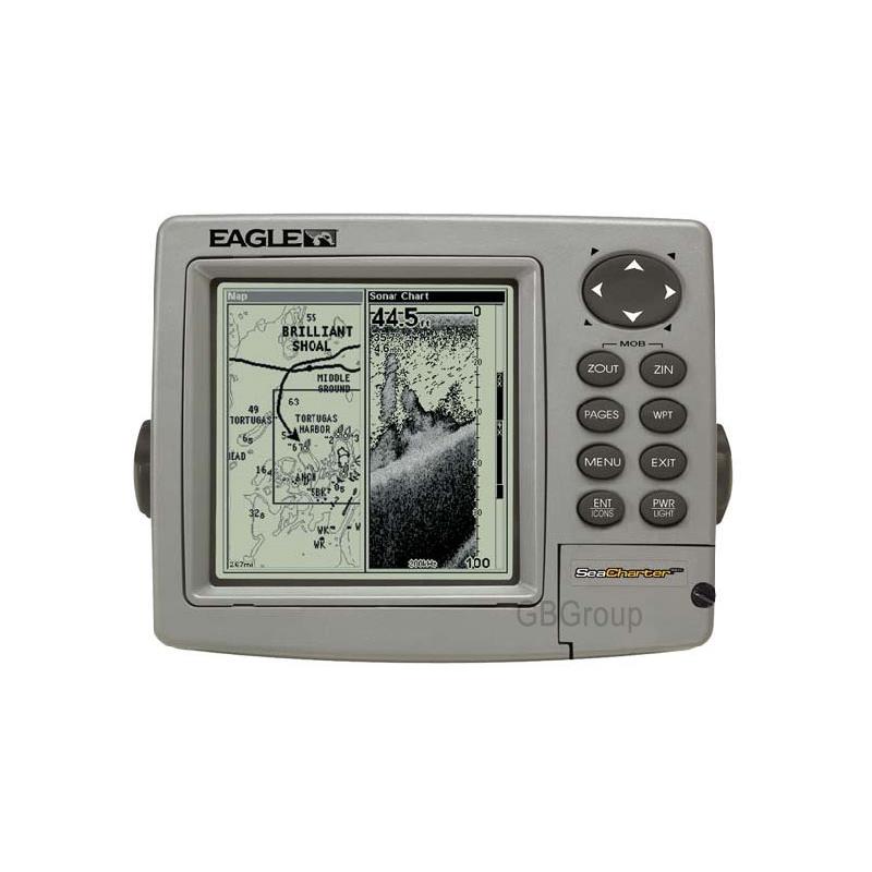
Eagle Seacharter 480 Df Chartplotter/Fishfinder
Eagle SeaCharter 480 DF Chartplotter/Fishfinder
The Eagle SeaCharter 480 DF Chartplotter is a high-performance, high-detail, dual-frequency sounder for depths down to 1500 ft plus precision GPS+WAAS navigation with multiple electronic chart options.
The Eagle SeaCharter 480 DF is a truly smart choice for coastal and Lakes use and for overall value.
Features
Display- 5-inch (12.7-cm) diagonal screen
- Film SuperTwist LCD
- High-definition 480 x 480 resolution
- Amber LED backlit screen and keypad
- 16-level greyscale
- Overlay data feature displays GPS data on sonar screens and sonar data on GPS screens
- Resize window feature allows width adjustment of either picture panel when in split-screen display
- Digitally record/play sonar graphs and GPS trip details with optional, reuseable compact Multi-Media Cards (MMC) or Secure Digital (SD) memory cards plus one waterproof slot for instantly-expandable memory using a single 8-512 MB card
- Depth capability to 1500 ft* (457 m) with 4000 W of peak-to-peak power (500W RMS)
- High-performance, low-profile 50/200 kHz Skimmer dual-frequency transducer with built-in temperature sensor delivers an extra-wide angle of fish detection area with high sensitivity settings - operates at boat speeds up to 70 mph (61 knots)
- SP-U transom-mount sensor included for precise trolling speed/distance log readings
- FishReveal feature exposes fish targets hidden in surface clutter, weed beds, thermoclines and other types of underwater cover
- HyperScroll feature locates and displays fish targets at higher boat speeds
- FasTrack vertical bar flasher displays real-time sonar returns and relative strength of each target
- Advanced Signal Processing (ASP) automatically adjusts your settings for the best sonar picture
- Patented greyLINE separates fish from nearby structure and bottom
- Advanced Fish ID shows underwater targets in different sizes of fish symbols
- FishTrack displays target depth readings above fish symbols
- Surface water temperature readings come from a built-in temperature sensor in the transducer
- Zoom with zoom bottom tracking and easy zoom-in/out control
- Selective on/off sonar alarms: Shallow, Deep and Fish
GPS+WAAS
- 12-parallel channel GPS+WAAS reception with fast satellite lock-ons, precise tracking and position updates every second with the external EGC-12W receiver
- Selectable on/off WAAS reception for enhanced position accuracy to 3 m (under 10 ft) at select locations
- All-new, built-in Eagle background map with enhanced continental US and Hawaii detail including navigational aids
- High-speed map screen updates
- Optional GPS Mapping Accessories Pack with MapCreate CD software that:
- Lets you create unlimited, custom, detailed maps on MMC or SD memory cards
- Includes unique, searchable database of streets, addresses and over 700,000 Pointss-of-Interest (POI) to easily find/identify marinas, restaurants, airports, emergency services and more
- Saves up to 1,000 waypoints, 1,000 event markers and 100 routes (up to 100 waypoints/route)
- 100 saveable plot trails with up to 10,000 points per trail
- 42 graphic icons to mark your favourite spots
- 38 map zoom ranges from 0.04 to 4,000 miles with easy zoom-in/out control
- Compatible with optional plug-and-play Lowrance FreedomMaps, Fishing Hot Spots Elite, LakeMaster Pro Maps and Navionics electronic charts on MMC/SD cards
Performance
- Internal back-up memory keeps stored GPS data and sonar settings safe and accessible for years
- Completely sealed and waterproof, even for use in harsh saltwater environments
- Full 1-year warranty
Eagle Seacharter 480 Df Chartplotter/Fishfinder
Unavailable