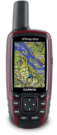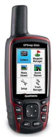
The Garmin GPSMap 62stc Handheld GPS Unit is an impressive GPS unit that includes among its features a 3-axis tilt-compensated compass, a barometric altimeter, a 5mpx autofocus camera with photo navigation, pre-loaded European Topo maps with support for custom maps and Garmin BirdsEye satellite imagery (subscription required).
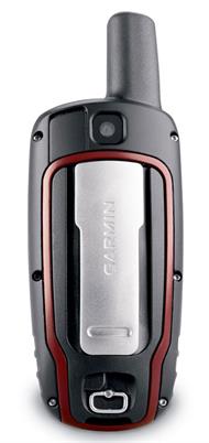
A durable waterproof and sleek unit, the Garmin GPSMAP 62stc boasts a quad helix antenna that provides excellent reception, it has a high-speed USB connection and it connects wirelessly to compatible Garmin handhelds.
The built-in 3-axis tilt-compensated electronic compass shows your heading even when you are standing still not even holding the unit level. Its barometric altimeter tracks changes in pressure to pinpoint your precise altitude and you can even use it to plot barometric pressure over time, which can help you keep an eye on changing weather conditions.
The slim and lightweight Garmin GPSMAP 62stc enables you to wirelessly share your waypoints, tracks, routes and geocaches wirelessly with other compatible Garmin device users so that your friends can also enjoy your favourite hike or cache. You simply press 'send' to transfer your information to similar units.
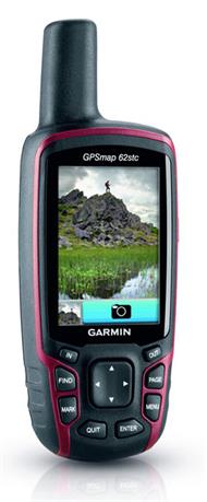
With the built-in 5mpx autofocus camera, you are able to capture the highlights of your outings. Each photo is automatically geotagged with the location of where it was taken, allowing you or anyone you share your photos with to navigate back to that spot in the future.
With its quad helix antenna and high-sensitivity WAAS-enabled GPS receiver and HotFix satellite prediction, the Garmin GPSMap 62stc Handheld GPS Unit locates your position quickly and precisely and maintains its GPS location even in heavy leaf cover and in deep valleys.
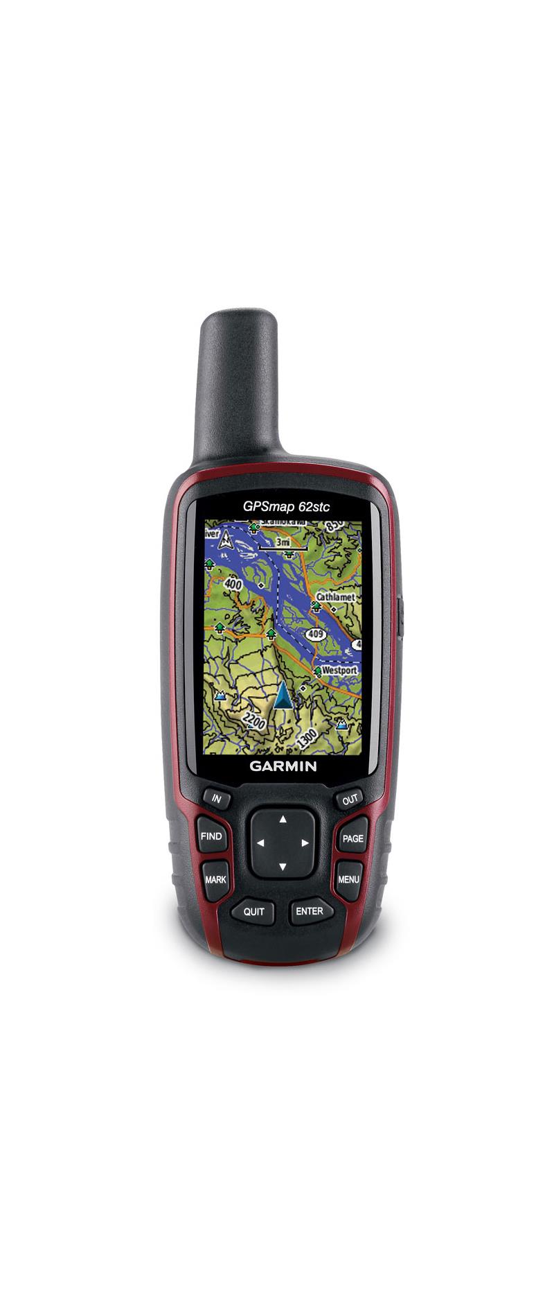
Adding more maps is easy with Garmin's wide choice of detailed topographic, marine and road maps. With 4.3GB of onboard memory, the GPSMAP 62stc allows you to conveniently download maps, plug in BlueChart g2 pre-loaded cards for a great day on the water or add City Navigator NT map data for turn-by-turn routing on roads. The Garmin GPSMAP 62stc also supports BirdsEye satellite imagery (subscription required) that lets you download satellite images to your device and integrate them with your maps. In addition, this unit is compatible with Custom Maps, free software that transforms paper and electronic maps into downloadable maps for your device.
With a simple connection to your computer and to the Internet, you can get a detailed analysis of your activities and send tracks to your Garmin outdoor device using Garmin Connect. This one-stop community website offers an activity table and allows you to view your activities on a map using Google Earth. Explore other routes uploaded by millions of Garmin Connect users and share your experiences on Twitter and Facebook.
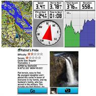
The Garmin GPSMap 62stc Handheld GPS Unit supports geocaching GPX files for downloading geocaches and details straight to your unit. The device stores and displays key information, including location, terrain, difficulty, hints and descriptions, which means no more manually entering coordinates or fussing with paper print outs. Simply upload the GPX file to your unit and start hunting for caches.
The Garmin GPSMap 62stc Handheld GPS Unit is an impressive GPS unit that includes among its features a 3-axis tilt-compensated compass, a barometric altimeter, a 5mpx autofocus camera with photo navigation, pre-loaded European Topo maps with support for custom maps and Garmin BirdsEye satellite imagery (subscription required).
A durable waterproof and sleek unit, the Garmin GPSMAP 62stc boasts a quad helix antenna that provides excellent reception, it has a high-speed USB connection and it connects wirelessly to compatible Garmin handhelds.
The built-in 3-axis tilt-compensated electronic compass shows your heading even when you are standing still not even holding the unit level. Its barometric altimeter tracks changes in pressure to pinpoint your precise altitude and you can even use it to plot barometric pressure over time, which can help you keep an eye on changing weather conditions.
The slim and lightweight Garmin GPSMAP 62stc enables you to wirelessly share your waypoints, tracks, routes and geocaches wirelessly with other compatible Garmin device users so that your friends can also enjoy your favourite hike or cache. You simply press 'send' to transfer your information to similar units.
With the built-in 5mpx autofocus camera, you are able to capture the highlights of your outings. Each photo is automatically geotagged with the location of where it was taken, allowing you or anyone you share your photos with to navigate back to that spot in the future.
With its quad helix antenna and high-sensitivity WAAS-enabled GPS receiver and HotFix satellite prediction, the Garmin GPSMap 62stc Handheld GPS Unit locates your position quickly and precisely and maintains its GPS location even in heavy leaf cover and in deep valleys.
Adding more maps is easy with Garmin's wide choice of detailed topographic, marine and road maps. With 4.3GB of onboard memory, the GPSMAP 62stc allows you to conveniently download maps, plug in BlueChart g2 pre-loaded cards for a great day on the water or add City Navigator NT map data for turn-by-turn routing on roads. The Garmin GPSMAP 62stc also supports BirdsEye satellite imagery (subscription required) that lets you download satellite images to your device and integrate them with your maps. In addition, this unit is compatible with Custom Maps, free software that transforms paper and electronic maps into downloadable maps for your device.
With a simple connection to your computer and to the Internet, you can get a detailed analysis of your activities and send tracks to your Garmin outdoor device using Garmin Connect. This one-stop community website offers an activity table and allows you to view your activities on a map using Google Earth. Explore other routes uploaded by millions of Garmin Connect users and share your experiences on Twitter and Facebook.
The Garmin GPSMap 62stc Handheld GPS Unit supports geocaching GPX files for downloading geocaches and details straight to your unit. The device stores and displays key information, including location, terrain, difficulty, hints and descriptions, which means no more manually entering coordinates or fussing with paper print outs. Simply upload the GPX file to your unit and start hunting for caches.