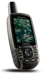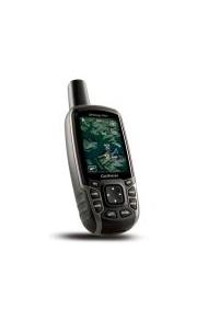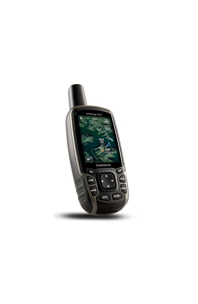
This is a robust and waterproof GPS that combines high-precision accuracy with a range of functions to see you through all sorts of expeditions.
The Garmin GPSMAP 62st is supplied with built-in European 1:100k recreation maps with street-level detail and a worldwide basemap with shaded relief, thus giving you what you need for serious climbing and hiking in urban and country locations.
The map detail includes national and local parks and forests including terrain contours, elevation information, trails, rivers, lakes and points of interest.
The Garmin GPSMAP 62st Handheld GPS Navigator also has a 2.6-inch sunlight-readable colour screen and it supports photo navigation.
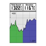
The GPSMAP 62st has a built-in 3-axis tilt-compensated electronic compass which helps you orientate yourself and points you towards your destination even if you are standing still you are not holding the unit level. Its barometric altimeter tracks changes in pressure to pinpoint your precise altitude.
You can view elevation and profile on the altimeter screen and you can even plot barometric pressure over time to keep an eye on changing weather conditions.
With the Garmin GPSMAP 62st, you can share your waypoints, tracks, routes and geocaches wirelessly with other compatible Garmin GPS handheld units so that your friends can also enjoy your favourite hike or cache. Just press 'send' to transfer your information to similar units.
With its quad helix antenna and high-sensitivity, WAAS-enabled GPS receiver with HotFix satellite prediction, the Garmin GPSMAP 62st GPS has unparalleled reception to locate your position quickly and precisely and maintains its GPS location even in heavy forest cover and in deep valleys.
With space to store up to 2000 waypoints and 200 routes, the Garmin GPSMAP 62st provides detailed route planning and tracking that helps you navigate from point to point and keep track of your journey as you go. As you navigate to a destination on an active track, you can view upcoming elevation changes together with waypoints and key stages along the route for a clear picture of the journey ahead.
With a simple connection to your computer and to the Internet, you can get a detailed analysis of your activities and send tracks to your outdoor device using Garmin Connect. Simply upload activities saved on the Garmin GPSMAP 62st from your hiking, camping or geocaching adventures to keep a record on the web or swap ideas and expeditions with others. This community site offers an activity table and allows you to view your activities on a map using Google Earth. Explore other routes uploaded by millions of Garmin Connect users and share your experiences on Twitter and Facebook.
This GPSMAP 62st Handheld GPS supports geocaching GPX files for downloading geocaches and details straight to your unit. By going paperless, you are not only helping the environment but saving time you would otherwise waste manually entering cache details before you set off.
The Garmin GPSMAP 62st Handheld GPS Navigator stores and displays key information, including location, terrain, difficulty, hints and descriptions, which means no more manually entering coordinates or paper print outs! Simply upload the GPX file to your unit and start hunting for caches.
This is a robust and waterproof GPS that combines high-precision accuracy with a range of functions to see you through all sorts of expeditions.
The Garmin GPSMAP 62st is supplied with built-in European 1:100k recreation maps with street-level detail and a worldwide basemap with shaded relief, thus giving you what you need for serious climbing and hiking in urban and country locations.
The map detail includes national and local parks and forests including terrain contours, elevation information, trails, rivers, lakes and points of interest.
The Garmin GPSMAP 62st Handheld GPS Navigator also has a 2.6-inch sunlight-readable colour screen and it supports photo navigation.
The GPSMAP 62st has a built-in 3-axis tilt-compensated electronic compass which helps you orientate yourself and points you towards your destination even if you are standing still you are not holding the unit level. Its barometric altimeter tracks changes in pressure to pinpoint your precise altitude.
You can view elevation and profile on the altimeter screen and you can even plot barometric pressure over time to keep an eye on changing weather conditions.
With the Garmin GPSMAP 62st, you can share your waypoints, tracks, routes and geocaches wirelessly with other compatible Garmin GPS handheld units so that your friends can also enjoy your favourite hike or cache. Just press 'send' to transfer your information to similar units.
With its quad helix antenna and high-sensitivity, WAAS-enabled GPS receiver with HotFix satellite prediction, the Garmin GPSMAP 62st GPS has unparalleled reception to locate your position quickly and precisely and maintains its GPS location even in heavy forest cover and in deep valleys.
With space to store up to 2000 waypoints and 200 routes, the Garmin GPSMAP 62st provides detailed route planning and tracking that helps you navigate from point to point and keep track of your journey as you go. As you navigate to a destination on an active track, you can view upcoming elevation changes together with waypoints and key stages along the route for a clear picture of the journey ahead.
With a simple connection to your computer and to the Internet, you can get a detailed analysis of your activities and send tracks to your outdoor device using Garmin Connect. Simply upload activities saved on the Garmin GPSMAP 62st from your hiking, camping or geocaching adventures to keep a record on the web or swap ideas and expeditions with others. This community site offers an activity table and allows you to view your activities on a map using Google Earth. Explore other routes uploaded by millions of Garmin Connect users and share your experiences on Twitter and Facebook.
This GPSMAP 62st Handheld GPS supports geocaching GPX files for downloading geocaches and details straight to your unit. By going paperless, you are not only helping the environment but saving time you would otherwise waste manually entering cache details before you set off.
The Garmin GPSMAP 62st Handheld GPS Navigator stores and displays key information, including location, terrain, difficulty, hints and descriptions, which means no more manually entering coordinates or paper print outs! Simply upload the GPX file to your unit and start hunting for caches.