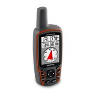
 Garmin GPSMAP 62s Handheld GPS Navigator
The Garmin GPSMAP 62 Handheld GPS Navigator is a durable and waterproof GPS unit with an impressive roster of features. These include the quad helix antenna and high-sensitivity WAAS/EGNOS-enabled GPS receiver with HotFix satellite prediction which means the GPSMAP 62 has the precision reception to locate your position quickly and accurately. It also maintains its GPS location fix even in heavy foliage cover and in deep valleys so this is a GPS unit that you rely on.
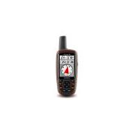
The Garmin GPSMAP 62 is equipped with a 2.6-inch sunlight-readable colour screen with a built-in worldwide basemap with shaded relief for navigating anywhere you please.
With space to store up to 2000 waypoints and 200 routes, the Garmin GPSMAP 62 Handheld GPS Navigator’s detailed route planning and tracking helps you to navigate from point to point and to keep track of your journey as you go.
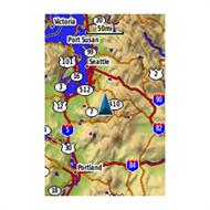
As you navigate to a destination on an active track, you can view upcoming elevation changes together with waypoints and key stages along the route for a clear image of the journey ahead. The customisable display allows you to adapt the Garmin GPSMAP 62 dashboard to display the details you need on your expedition.
The Garmin GPSMAP 62 Handheld GPS Navigator can easily add more maps to the built-in worldwide basemap using Garmin's wide choice of detailed topographic, marine and road maps, which can be loaded to the unit’s internal memory.
With a simple connection to your computer and to the Internet, you can get a detailed analysis of your activities and you can also send data to your outdoor device using the Garmin Connect website to store, save and share your routes, tracks and waypoints. The Garmin Connect site offers an activity table and allows you to view your activities on a map using Google Earth. You can also explore other routes uploaded by millions of Garmin Connect users and share your experiences on Twitter and Facebook and it is all straightforward to do.
The Garmin GPSMAP 62s lets you wirelessly share your waypoints, tracks, routes and geocaches with other compatible Garmin GPS handhelds.
The Garmin GPSMAP 62 Handheld GPS Navigator has a built-in 3-axis tilt-compensated electronic compass which helps you orientate yourself and directs you towards your destination even when you are standing still and without having to hold the unit level.
Its barometric altimeter tracks changes in pressure to pinpoint your precise altitude so you can view elevation and profile on the altimeter screen and you can even plot barometric pressure over time to keep an eye on changing weather conditions.
The Garmin GPSMAP 62 Handheld GPS Navigator supports geocaching GPX files for downloading geocaches and details straight to your unit and by going paperless, you are helping the environment but saving time you would otherwise waste manually entering cache details before you set off.
The Garmin GPSMAP 62 stores and displays key information, including location, terrain, difficulty, hints and descriptions, which means no more manual entering of coordinates or having to deal with paper print outs. Simply upload the GPX file to your unit and start hunting for caches.
The slim and lightweight Garmin GPSMAP 62 Handheld GPS Navigator is the perfect GPS unit for all your outdoor pursuits.
The Garmin GPSMAP 62 Handheld GPS Navigator is a durable and waterproof GPS unit with an impressive roster of features. These include the quad helix antenna and high-sensitivity WAAS/EGNOS-enabled GPS receiver with HotFix satellite prediction which means the GPSMAP 62 has the precision reception to locate your position quickly and accurately. It also maintains its GPS location fix even in heavy foliage cover and in deep valleys so this is a GPS unit that you rely on.
The Garmin GPSMAP 62 is equipped with a 2.6-inch sunlight-readable colour screen with a built-in worldwide basemap with shaded relief for navigating anywhere you please.
With space to store up to 2000 waypoints and 200 routes, the Garmin GPSMAP 62 Handheld GPS Navigator’s detailed route planning and tracking helps you to navigate from point to point and to keep track of your journey as you go.
As you navigate to a destination on an active track, you can view upcoming elevation changes together with waypoints and key stages along the route for a clear image of the journey ahead. The customisable display allows you to adapt the Garmin GPSMAP 62 dashboard to display the details you need on your expedition.
The Garmin GPSMAP 62 Handheld GPS Navigator can easily add more maps to the built-in worldwide basemap using Garmin's wide choice of detailed topographic, marine and road maps, which can be loaded to the unit’s internal memory.
With a simple connection to your computer and to the Internet, you can get a detailed analysis of your activities and you can also send data to your outdoor device using the Garmin Connect website to store, save and share your routes, tracks and waypoints. The Garmin Connect site offers an activity table and allows you to view your activities on a map using Google Earth. You can also explore other routes uploaded by millions of Garmin Connect users and share your experiences on Twitter and Facebook and it is all straightforward to do.
The Garmin GPSMAP 62s lets you wirelessly share your waypoints, tracks, routes and geocaches with other compatible Garmin GPS handhelds.
The Garmin GPSMAP 62 Handheld GPS Navigator has a built-in 3-axis tilt-compensated electronic compass which helps you orientate yourself and directs you towards your destination even when you are standing still and without having to hold the unit level.
Its barometric altimeter tracks changes in pressure to pinpoint your precise altitude so you can view elevation and profile on the altimeter screen and you can even plot barometric pressure over time to keep an eye on changing weather conditions.
The Garmin GPSMAP 62 Handheld GPS Navigator supports geocaching GPX files for downloading geocaches and details straight to your unit and by going paperless, you are helping the environment but saving time you would otherwise waste manually entering cache details before you set off.
The Garmin GPSMAP 62 stores and displays key information, including location, terrain, difficulty, hints and descriptions, which means no more manual entering of coordinates or having to deal with paper print outs. Simply upload the GPX file to your unit and start hunting for caches.
The slim and lightweight Garmin GPSMAP 62 Handheld GPS Navigator is the perfect GPS unit for all your outdoor pursuits.
