
 Garmin eTrex 10 Handheld GPS Unit
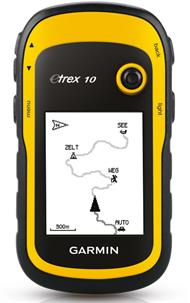
The Garmin eTrex 10 Handheld GPS Unit is an extremely reliable handheld GPS device whose functions, durability and long battery life have made it such a successful core member of the Garmin GPS range.
The Garmin eTrex 10 has an enhanced 2.2-inch monochrome display that is easy to read in any lighting conditions with its easy-to-use interface that lets you use the results with ease.
The waterproof eTrex 10 GPS Unit can withstand dust, dirt, humidity and water so it is an ideal outdoors device.
The Garmin eTrex 10 features paperless geocaching by supporting GPX files for downloading geocaches and details straight to your unit. By going paperless, you're not only helping the environment but also making your geocaching more fun and more efficieint.
The Garmin eTrex 10 stores and displays all the information you need, including location, terrain, difficulty, hints and descriptions, which means no more manually entering coordinates and paper print outs. Simply upload the geocache to your unit and start hunting for caches.
With its high-sensitivity, EGNOS-enabled GPS receiver and HotFix satellite prediction, the Garmin eTrex 10 Handheld GPS locates your position quickly and precisely and maintains its GPS location even in heavy foliage cover and deep valleys.
The eTrex series receivers can track both GPS and GLONASS satellites simultaneously. GLONASS is a system developed by the Russian Federation that has been fully operational since 2012. When using GLONASS satellites, the time it takes for the receiver to lock on to a position is on average approximately 20% faster than using GPS. And when using both GPS and GLONASS, the receiver has the ability to lock on to 24 more satellites than using GPS alone.
