


Memory-Map CAA Aviation 1:500,000 Charts
Memory-Map CAA Aviation Charts
Memory-Map CAA Aviation Charts are Digital CAA 1:500,000 and 1:250,000 VFR charts for the UK available on CD for use with Memory-Map Software.
Chart Box Photo
A variety of titles are available, containing your choice of 1:250,000 or 1:500,000 VFR charts which can be used on PC, Pocket PC, Smartphone and now the Road Angel Adventurer PND (Portable Navigation Device). The full product includes the intuitve and powerful Memory-Map V5 software. Licensed aerodrome plans are available as a FREE download to include in your Memory-Map software.
Map on Laptop
Use on a PC at home...
Plan flights, see waypoints, program GPS and review GPS flight data then print off custom VFR charts.
Use with a Pocket PC on board...
A full in-flight moving VFR chart shows the real-time position, "Go-to Waypoint" or "Follow Route" visual display bearings and flight track.
Use on land as well as in the air...
Memory-Map also works with detailed full colour Ordnance Survey maps. You can use the same system to research take-off or landing sites, particularly useful for locating farm strips.
In addition, favourite walks and bike rides can be planned. Aerial photographic maps can be added to check VRPs before you fly.
Review your performance...
Import GPS tracks and see exactly where you've flown, your speed, your altitude as well as the ground elevation and distance covered on your flight.
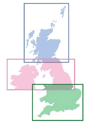
| Memory-Map CAA 1:500,000 | Scotland Northern England and Northern Ireland Southern England and Wales |
 |
|
Memory-Map CAA 1:250,000 |
|
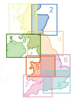 |
1. Northern Scotland West 2. Northern Scotland East 3. Northern Ireland 4. The Borders 5. Central England and Wales 6. England East 7. England West and South Wales 8. England South |
Unavailable